about 9 miles; +2,085 ft elevation
 We bid sad farewell to two thirds of our resupply party and hit the trail late, newly joined by the other third... our compadre in art crime: Stin-G B! who would finish the trail with us and who's car was waiting for us at Whitney Portal. At this point our gravity water filter had failed completely so we relied entirely on Stin-G's pump filter which worked splendidly.
 We had a full day of hiking, thought we might camp at the Center Basin JCT which was big and nice and beside a stream but we felt like marching on. We forged ahead to extremely windy and quite crowded plateau below Forester Pass. We got in a bit late so many good sites were taken by other campers. Not knowing for certain if the wind was due to the typical temperature shift that comes with sunset (it was), we settled for a mediocre site immediately next to the trail because it did have a wind break of rocks and trees. We discovered later as we strolled around that there are plenty of great sites just east of the trail, and actually there were two excellent, tiny sites on pine duff perched along the ledge behind where most folks had camped.
 But our site was perfect with amazing views of the squarish Aztec pyramid peak (that we somehow never saw again on our climb up to the pass) and a most amazing waterfall streaming down blackened rock face which we'd have missed in the late day shadows. Thankfully our ears led our eyes to it. It may be the most striking falls on the JMT.
 about 10 miles; +1,980 ft; -1,780 ft elevation
Got over Forester Pass in the morning. It was very smoky by the time we got to the top due to fires nearby. We were held hostage to the full throated, insipid conversations of other hikers at the pass. A shame because the place seemed to us to command total attention. The descent is harrowing to the eyes, steep dropoffs the result of some impossible trail-building. If not courage, it was our desire to escape the chatty crowds that spurred us on. Much as we wanted to gain distance, we had to stop at the gold and orange stream that suddenly gives rise to thick green grass in the middle of the desolate foothills.
Most folks stop for the night at Tyndall which has great swimming holes, but we pressed ahead and pitched a stealth camp at the Jodorowsky -esque Bighorn Plateau. The sheer spookiness of the place put us on lookout for naked children on horseback among the ancient Foxtail Pine.

8 September 2010

about 20 miles; +3,500 ft; -6,200 ft elevation


Views back up to Mt. Whitney , now framed in charcoal storm clouds, were quite different from what we'd seen on our ascent. From this side, those spires are the most prominent feature of the summit. The rounded top, with its stone hut, are only barely and briefly visible from the east. We continued down the mountain -- never ending switchbacks. NEVER ENDING SWITCHBACKS! Never have humans more clearly resembled insects marching in line.
 But our site was perfect with amazing views of the squarish Aztec pyramid peak (that we somehow never saw again on our climb up to the pass) and a most amazing waterfall streaming down blackened rock face which we'd have missed in the late day shadows. Thankfully our ears led our eyes to it. It may be the most striking falls on the JMT.
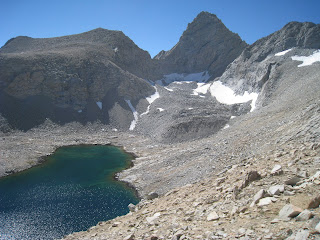
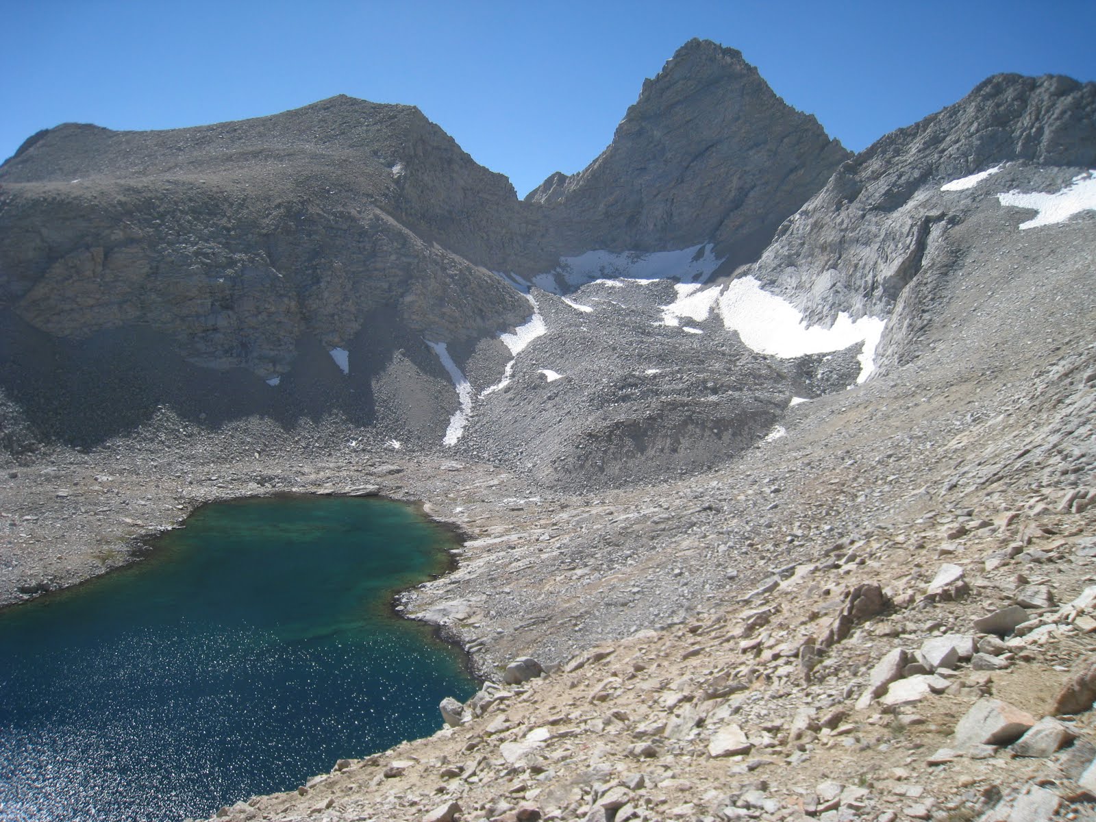
The following day we'd climb past lake 12,270' (pictured), nearly halfway to the pass, where it would have been possible to camp on strangely flat slabs that were dynamited to create... strangely flat slabs just large enough for a tent. A bit too far, we would've been late and spent had he tried to make this lake in a day coming from Kearsarge Lakes. Nonetheless, it's a brilliant option to bear in mind for future.
5 September 2010 - meadow below Forrester Pass to Bighorn Plateau
5 September 2010 - meadow below Forrester Pass to Bighorn Plateau
| 6mi (1600’) 500’ D=8 | Don’t Start Late. Forrester Pass. (CalTech Peak detour - 4hours “Go W across outlet of 2nd large lake just south of Forr pass. Ascend twd northwest to ridge south of Caltech. Easy traverse to summit.) C24 - Bighorn Plateau (Tawny Pt. detour- 2hours roundtrip “head slightly northeast xcountry, then north up the southern slope of Tawny Point, no obstacles or talus.) |

Got over Forester Pass in the morning. It was very smoky by the time we got to the top due to fires nearby. We were held hostage to the full throated, insipid conversations of other hikers at the pass. A shame because the place seemed to us to command total attention. The descent is harrowing to the eyes, steep dropoffs the result of some impossible trail-building. If not courage, it was our desire to escape the chatty crowds that spurred us on. Much as we wanted to gain distance, we had to stop at the gold and orange stream that suddenly gives rise to thick green grass in the middle of the desolate foothills.
 |
| Foxtail Pines can live up to 3,000 years. |
 |
| Bighorn Plateau: great bird watching. |
 |
| Stin-G relaxing in a bit of shade. |
Instead, we watched a huge flock of Crows picking off millions of hoppers. Imposing as those black birds were, they grew wary as a Peregrine Falcon began dive bombing burrows, hugging the curvature of the plateau right along our line of sight. Unforgettable, and that wasn't all. The falcon then perched itself in a spectacularly dead tree not thirty feet from the trail where we stood. Pilastr fumbled so nervously for his camera, the falcon may have changed its opinion of us. It flew off.
6 September 2010
 about 8 miles; +1,200 ft elevation
Spent the morning photographing and exploring Bighorn Plateau while Pilastr and Stin-G went up to Tawny Point. We saw more birds of prey at close range, the huge flock of huge Ravens plus many large Marmot burrows heaped high with scat. Luckily the weather presented with blue skies; upon our exit we learned of parties that had been hit by lightening on Bighorn Plateau in recent years.
| 8mi (1000’) 600’ D=9.5 | ...Wright Wallace Whitney Creeks C25 - Guitar Lake/Arctic Lake Prefer Artic to shave one mile off Whitney summit day |

Spent the morning photographing and exploring Bighorn Plateau while Pilastr and Stin-G went up to Tawny Point. We saw more birds of prey at close range, the huge flock of huge Ravens plus many large Marmot burrows heaped high with scat. Luckily the weather presented with blue skies; upon our exit we learned of parties that had been hit by lightening on Bighorn Plateau in recent years.
After lunch we continued down the trail to cross Wright Creek then Wallace Creek and climb to Sandy Meadow at the point of Mt. Young. With Sandy Meadow at our feet and the spectacular Kaweah peaks further on, we took many a long break before finally striking out cross-country through the woods beside and above the meadow to make camp.
7 September 2010

En route to Guitar Lake for our final night before attempting to summit Mt. Whitney, we picked up our "wag bags" at the Crabtree Ranger's Station. We also got a weather report of an approaching cold front which cast a shadow on our hopes of summiting. For now, the weather couldn't have been better. We made good time and had our pick of tent sites above Guitar Lake. With ample daylight left, we ditched the arriving crowds at the trail and hiked up toward Arctic Lake where we found more amazing scenery and total seclusion. I took a shower in a waterfall (NO soap), sunbathed, Pilastr fished for the rest of the day and Stin-G scrambled clear up to Artic Lake. In the evening I wore every article of clothing I had and put the rest in my foot box anticipating a cold night. I stayed toasty warm. Our night at Forrester had been colder by far.
8 September 2010

| 9- 10.5mi 3400’ (2500’) D=16.5 | joe=”Start BEFORE DAWN!” Summit Mt. WhitneyC26 - Trail Camp =zoo “. “ put the fly on, batten down the hatches you can be in for a very cold windy night. Plan on temperatures into the 20s at night all during the summer. However, views are awesome.” Maybe continue just past Outpost trail camp where a small site is hidden just behind a hump. |
 |
| down, down, down to Whitney Portal |
 |
| descending on the East side |
It's essential to head for the summit of Mt. Whitney as early as possible. We'd been told noon should be our late goal since storm clouds almost always gather by then. For us, this rule held exactly so. At 7:45am, we were the very last group to leave Guitar Lake; but not last to the top. We were supercharged from nearly four weeks of hiking and extremely happy to be nearing trail's end, which is technically the top of Mt. Whitney and highest point in the lower 48 states except... practically, you also have to hike yourself off that peak!
For the first time on the trek, I got blisters; but I didn't care. It was a very windy morning and we found ourselves not warming up with hiking alone so our parkas and rain/wind layers stayed on all day. Pilastr lost all feeling in his fingers and nose. Hiking without poles so he could shove his hands into his armpits helped the fingers, his nose tried to hide in his hood. The wind got increasingly painful the higher we got but the excitement of the end of the trail overrode all discomfort.

It wasn't clear how this trail was going to take us over the vertical ridge, nothing for it but to keep pace. The steep ascent brought us incredible views to Hitchcock Lakes, Guitar Lake, the Kaweah peaks, Mt. Muir, then more peaks than we can name. The appearance of sun on the trail ahead seemed like it should bring warmth, no luck. Biting wind would be the name of the game all day long. At narrow ledge of Trail Crest we dropped our packs alongside forty others and took only water and snacks up to Mount Whitney summit.
We knew this day would be an endurance challenge. Thinking on that is maybe why we hadn't anticipated the beauty, and sheer exposure, of this last stretch of the JMT. The trail passes along a very narrow ridge with uneven footing, some rather high steps, and heavy consequences should your toe grab on one of the many jutting edges of the Earth. We simply had no idea we'd be passing between those fifty foot spires that are so distinctive of Mt. Whitney's profile, nor did we translate those spires into the four thousand foot sheer drops down to shimmering glacial tarns we now found ourselves frozen tip-toeing across. At one point in particular, a three foot step down brings you just beyond a solid rock wall such that, upon landing the step, you suddenly find yourself inches from the full plunge. Pilastr's stomach flipped like a fish. Hands too cold to work a camera, there are not many photos from this stretch. But here's one...

To reach the summit is exhilarating, and cold. While there is a hut, only one small room is accessible and really there are better wind breaks among the boulders or in back of the hut itself. The summit is very broad, which is lucky because with a hundred or more people up there at a time you wouldn't want jostling! The winds tested our mettle with regard to how near the edge we were willing to inch. And really there's no reason, views are generous and sublime in every direction. Don't forget to look straight up, since you're as near to space as you can be on two feet in the lower 48! Some folks plan to celebrate with booze

etc, don't bother; any expectations can only interfere: taking in where you are, who you're with, and how you all got there will occupy your senses quite completely.
The noon clouds began to gather and the incessant winds prompted our descent toward Whitney Portal. We weren't sure how far we would get but the cold weather and accumulating storm clouds provided incentive. On the Trail Camp side of Whitney (and interestingly, not on the Guitar Lake side), the amazing scenery was marred by white dots of stowed toilet paper wads here and there all the way down the trail severely impacting our faith in humanity. Please see the Wilderness Bidet tab for a description of the system we found most environmentally friendly and tidy -- no toilet paper necessary!
Views back up to Mt. Whitney , now framed in charcoal storm clouds, were quite different from what we'd seen on our ascent. From this side, those spires are the most prominent feature of the summit. The rounded top, with its stone hut, are only barely and briefly visible from the east. We continued down the mountain -- never ending switchbacks. NEVER ENDING SWITCHBACKS! Never have humans more clearly resembled insects marching in line.

It had been a very full day, our plan on paper had been to stop at Outpost Camp. Instead, the crowds, incessant wind and threatening rain convinced us to tough it out and turn this into a 20 mile day complete with 3000' foot ascent and 6500' descent! The promise of beer, burgers, and a hot tub made it a short decision to step lively and make Whitney Portal. This wasn't an easy decision, but it was the right one particularly because the trail below Outpost Camp is less steep, more well defined, and seemed about two miles shorter than what our maps suggested.
At Whitney Portal we tied into cheeseburgers, fries, and a six pack of beer and sneered at the scavenger jays. From the bear lockers there (Stin-G had taken no chances leaving anything in his car following an early season bear attack in Yosemite Valley that nearly destroyed his car despite there being NOTHING inside,) we retrieved our exit bags with clean clothes and just stared at them, saving them til we'd had our hot showers at the motel in Bishop. It was the cleanest dirt on earth; but finally it was time to excavate it from our fingerprints.
 |
| cleanest dirt on earth! |
No comments:
Post a Comment