| 9mi +1760 4% D=10.7 | ..On to Evolution Meadow and Franklin Mdw C14 - From McClure Meadows, ascend a bit to campsites at Colby Meadow, Next sites 10mi |

Woke up early and forded the ice cold San Joaquin River in order to reach the paradisaical Blaney Hot Springs for a soak at dawn. As we passed through the meadow to the springs we noticed the flowers were all covered in sleeping bumblebees. I guess they were too busy to bother returning to their hives and spent the night clinging to their flowers and it was still too cold for them to start moving again. We also spotted a Rubber Boa in the middle of the trail which seemed to be asleep.
We stopped back at the ranch to collect our lunch and dinner which wouldn't fit in the can (given that it was crammed with an 8 day supply already). Lucky too since the mail Humvee had just pulled up with messages and photos from home! Extremely welcome. But some clouds had appeared, we had ground to cover, so the letters got a quick perusal, quick folding, and off we went toward Evolution Valley.

Soon after leaving Muir Trail Ranch we found ourselves in a dramatic black woods. We paused beside a pond so thick organic decay it reflected the charcoal colored trees, some of which had toppled into it. Gorgeous. Distant thunder made us think we might see our first rain, it never came. The San Joaquin is a tremendous river, signs of higher water were everywhere. Huge trees had been pinned between boulders on the canyon wall. It only gets better as canyon walls get steeper choking the river into violent rapids.
We cooled off with a swim under a bridge, soft sandy bottom and trout rising to feed. The climb to Evolution Valley was long and packs were heavy, especially for Pilastr who was carrying all the food. Though the best sites were north of the McClure Meadow Ranger's Station, they had been claimed and we found ourselves too worn out and the sun too low for a lengthy site search. We pitched camp near the trail in a large established site with an expertly made fire ring. This can have its advantages as we befriended a solo hiker, Glen, who already had a fire blazing. Good company, he tipped us off to great loop hikes around there, and about a museum in Martinez on the site of John Muir's former home.

27 August 2010 - McClure Meadows to Saphire Lake
| 6- 7mi? Why 10mi warn? +1900’ 4% D=10 | Don't start late, in good weather consider shortday or zeroday at Darwin's Bench (top of the last switchback, ptarmigan!) C15 - At Saphire Lake outlet, turn to walk east shore to small campsites on south side. (Possible detour to Mt. Spencer) If stormy, camp earlier and lower near Evolution Lake. |

Left the spectacular Evolution Valley toward Muir Pass. The lovely Colby Meadow below Evolution Lake was full of wranglers and their horses when we arrived or we might have lingered there for lunch. Instead, we continued on the steady climb to the spectacular Evolution Lake. Something about the roller-coaster swerve of the trail, the steep enclosing peaks and mountain peninsula jutting into the lake sets this place apart. Deep furrows beside the lake made for a natural easy chair during lunch too!
Pressing on to Sapphire Lake, the basin above Evolution becomes spectacularly wide, so much so that trail builders have placed thirty or more huge stepping stones across the stream. It's a trip to cross it. Beyond, the Wilderness Press guide told us the best sites would be opposite from the trail on the East bank of Sapphire Lake. There were indeed level, sandy sites but we were still exposed to the high winds. Not so strong that Pilastr didn't manage to cast into them. At the inlet, the trout were tiny but plentiful and fun to catch though the shores are so soft that he kept sinking past his ankles and nearly losing his footwear.

We saw no one else at Sapphire Lake, til morning when we barely made out a couple who must have arrived late and stayed on the trail side. We spoke to other folks later that day who had chosen to sleep lower at Evolution Lake. They reported high winds as well; so it seems wind was an inescapable elemental that night. An immense bolder stands on its edge in the middle of Sapphire Lake. The waters are deep and blue but only fully showed us their beauty when we left, climbed above them, and looked back.
28 August 2010 - Saphire Lake to Grouse Meadow
| 14mi +560’ (3000’) D=10.5 | ...Wanda Lake (Black Giant detour?) past Lake McDermand up to Muir Pass and on to Helen Lake C16 - Granite is more likely than Metamorphic rock to have sandy campsites. Starrs Camp has lots of sites in direction of the creek and atop steep drop to Le Conte Cyn. Or contine down to Grouse Meadow Pass JCT |

The climb to Muir Pass would be unforgettable for its deep glacial water set in a barren lunarscape, if not for Muir Pass itself and the subsequent descent into Le Conte Canyon which is likely to make you forget it, for the time being anyway.
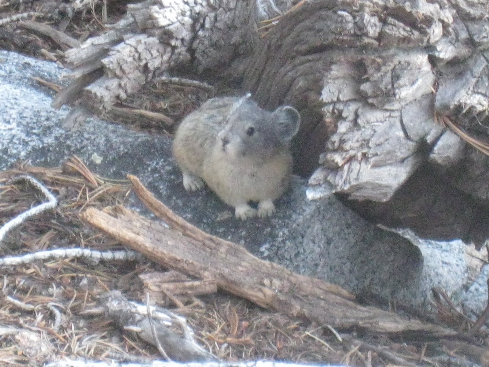
In the stone shelter at Muir Pass, got a weather report of cold temperatures and snow from some other hikers which seemed likely as the temperature had dropped. We cut our visit to the Muir Hut short and made a dash for lower climes. A shame to have to rush because this is simply the most beautiful stretch of the entire JMT. On the hike down we saw about ten Yellow Legged Frogs in the river. We crossed paths with an industrious Pika with a mouth full of green grass. It was like stepping on a cute bomb, our surly selves didn't survive. In spite of surreal views down the canyon, the looming Black Giant peak at our shoulder, the filigree of waterfalls, and hypnotizing fractals between deeply colored scree piles, we pretty much ran down the pass. This was necessary to avoid the storm and we were glad we did. Folks we spoke to later reported hail and freezing temperatures as low as Little Pete Meadow. We covered fifteen miles, stopping briefly to chat with the ranger who confirmed the storm reports. The camp near Bishop Trail JCT was packed, as were the many sites at Grouse Meadows. We nearly settled for a trailside fire ring, but luckily continued another mile to an excellent site near the river, secluded, equipped with a fire ring and among sheltering trees. We staid here two nights to avoid the full cold snap, knowing we'd have to make up for it by making steady time up the Golden Staircase!

29 August 2010 - Zero Day
0 miles, 0 elevation
Spent the day fishing and drawing. Brilliant. Kept the fire going too as it was quite cold.
30 August 2010 - Grouse Meadow to Upper Palisades Lake
 about 11 miles; +3,600 ft elevation
Broke camp early. Camp was cold and damp. We might have kept our tent and bags tied to the outside of our packs to dry out. We didn't, and they weren't fully dry when we next made camp. Luckly the cold had passed. Soon after turning up the Golden Staircase, we spotted a Fisher as it dashed across the trail. The critter surprised us when it doubled back to get a better look at us! We met trail builders as they passed us, one with a sledgehammer balanced on the hood of his pack. Criminy.

29 August 2010 - Zero Day
0 miles, 0 elevation
Spent the day fishing and drawing. Brilliant. Kept the fire going too as it was quite cold.
30 August 2010 - Grouse Meadow to Upper Palisades Lake
| 11mi +3600' 9.6% D=10 | C18 - Overlooking Palisades Lake are sandy tent sites under stunted white bark pines. Views! Lakes are 1500’ still below Mather pass |

Broke camp early. Camp was cold and damp. We might have kept our tent and bags tied to the outside of our packs to dry out. We didn't, and they weren't fully dry when we next made camp. Luckly the cold had passed. Soon after turning up the Golden Staircase, we spotted a Fisher as it dashed across the trail. The critter surprised us when it doubled back to get a better look at us! We met trail builders as they passed us, one with a sledgehammer balanced on the hood of his pack. Criminy.
The scree slopes flanking the Golden Staircase are dumbfounding, particularly because they halt at the edge of a charging river that breaks periodically into waterfalls. The trail here is well built but requires some high stepping. Luckily, you can break as often as you like and be rewarded with the long view back down the canyon. The higher you climb, the more gorgeous the vegetation and rock pinnacles. Near the end, desolate scree slopes have morphed into lush green shores and orange streams sparkling with trout belly.
 |
| chaos reigns! |
Lower Palisades Lake has many fish, and large fish. Pilastr dropped everything then and there to set up the fly rod. He wasn't disappointed. Thinking there'd be more fishing at upper Palisades Lake, we pressed on. Alas, the trail crosses very high above upper Palisades. To fish it would take more time than we had left in the day. A few sites, those right on the trail, have easy access to the stream. Per usual, these sites-of-least-resistance are first to be claimed. The far better sites (though less convenient maybe) were just a bit further up the trail, well-hidden among stunted white pine and affording insane views back down to Lower Palisades and beyond. From here, we enjoyed a visit from a scrappy but amiable Pika which basically vogued for Pilastr's camera.
31 August 2010 - Upper Palisades Lake to Taboose Pass

| 10.5mi 1500’up (2100’)down 750’back up D=14 | ...Fishing in stream BEFORE Pinchot Pass C19 - Taboose Pass |
No pass is easy, and Mather Pass is no exception. The moon descending toward the rim of peaks was reflected in small glacial ponds and every step on the trail made Pilastr re-shoot all the photos he had just shot. As you near the pass, the trail is constructed entirely of rubble. For stretches, the footing is extremely uneven and as a result extra tiresome. The false summit phenomenon is in effect here as well, but any experienced hiker knows not to predict a summit or rather, to ignore your predictions when inevitably... you do predict.
Views from Mather Pass will crown you for your labors. To the south we caught sight of the painted rocks that would make up Pinchot Pass. The long wide basin separating us made for excellent mediation, beginning with the incredibly long switchbacks that brought us down the southside of Mather Pass. We found ourselves staring down on the tops of trail workers heads, but it would take us a hundred steps to cross each switchback to get there. Forced off the trail by the trail building, you soon realize you're crossing an otherwise totally impassable steep of loose sand and rock. The wide switchbacks are a feat of engineering. Looking back up from the bottom, the trail vanishes completely into the slope.

Dropping down to stream level before our climb back up to the Taboose /Bench Lake Ranger's Station (en route to Pinchot Pass), Pilastr reminisced about his first trip to the Sierra when he followed his brother and friends on a cross country near death-march through the Muro Blanco (a treacherous bushwhack where John Muir himself took a spill that knocked him out cold). Pilastr took just such a spill on that trip, head met granite followed by a thirty foot spread-eagle friction slide toward a waterfall. Good times!
Above the ranger station but below Lake Marjorie, we camp at an unnamed lake that positioned perfectly for a morning ascent to Pinchot Pass. Woke up having lower back pain, I think from straining myself on the large steps of the Golden Staircase the previous day. Slow and steady.
1 September 2010 - Taboose Pass to just below Dollar Lake
about 13 miles; +998 ft; -3,638 ft elevation
 Hiked over Pinchot Pass in the morning and down the other side. Pinchot is spectacular, views of the Painted Lady, Marjorie and Twin Lakes and a first look at all that lay between us and Glen Pass. We met the uncle of the author of the Wilderness Press book. He was wielding a radio telemeter and tracking big horn sheep, two of which were somewhere in the crags immediately above us! We had a swell chat with him and his buddy then continued down through what was a hot, dusty, not quite so fun, slog. It was here that we first saw the smoke from a fire in SEKI's Crescent Meadow. This smoke persisted til we reached the shadow of Mt. Whitney.
1 September 2010 - Taboose Pass to just below Dollar Lake
| 15mi Rae 1350’ Pincht (1790’Wood +2000’ Rae D=13 | ...Pinchot Pass to C20 - Woods Creek joe=”crowds” (troutpools @upper creek) and Twin Lakes (upper is best). Rae Lakes large sites=shared. Camp sooner at Dollar Lake ("least fished in the area") or Arrowhead (S. Fork above is dry fly city; btw falls at inlet=great) |
about 13 miles; +998 ft; -3,638 ft elevation
 Hiked over Pinchot Pass in the morning and down the other side. Pinchot is spectacular, views of the Painted Lady, Marjorie and Twin Lakes and a first look at all that lay between us and Glen Pass. We met the uncle of the author of the Wilderness Press book. He was wielding a radio telemeter and tracking big horn sheep, two of which were somewhere in the crags immediately above us! We had a swell chat with him and his buddy then continued down through what was a hot, dusty, not quite so fun, slog. It was here that we first saw the smoke from a fire in SEKI's Crescent Meadow. This smoke persisted til we reached the shadow of Mt. Whitney.
 Just as we were fixing to declare ourselves hot, tired, and even bored, we came to the White Fork River crossing with its interesting bone white mineral deposits all over the river rocks. Looking back from Glen Pass, this white vein jumps out of the landscape as it cuts down the entire canyon wall.
Glad to reach shade, we were now in the thick of the smoke. Crowds we'd been told to expect at Woods Creek were nowhere to be seen. Apparently the fire had blocked easy access. Even so, the mere sight of bear cans made us want to push on. The climb toward Rae Lakes is lush, atop the canyon rim cypress trees seem to stand guard. We encountered a large buck hiding from us in a tangle of cottonwood. Lots to enjoy but we hiked beyond our energy reserves, passing one site set in the dead center of a swamp where the trail actually becomes a raised wooden walkway. Wary of becoming a bug feast, we pressed on and came to what would've been a perfect site where the trail dips down to a small gorge with an established site along the stream, except a hefty fisherman dude had already set up there. As we continued up, the landscape became more and more rocky or choked with deadwood, there was no apparent place to hope to pitch a tent. The topo lines suggested a flatter spot ahead, by the time we reached it we were spent. Still, dropping the pack and hauling ourselves to the stream for a bath worked wonders. The sky couldn't have been more clear, and we were just below 10,000 ft so we could cook over a twig cook to conserve fuel.

2 September 2010 - Dollar Lake to Kearsarge Lakes
| 11mi 3400’Glen (1200’)Charl D=14 | C21 - Charlotte Lake (joe=”not that nice”) or Rae Lakes or at JCT to 60 Lakes. Meet Joe early? If we can cross Glen Pass in time, he’ll be at Kearsarge Lakes. Otherwise tmrw at Vidette. |

Hit the trail early for Rae Lakes and Glen Pass. Found many other hikers on the trail, though curiously only one person camped beside the Rae Lakes, likely because of the fire in SEKI.
Crossing the stream between Arrowhead lake and the Rae Lakes, both our jaws dropped at the number of trout in the shallow brook there. A hundred fish at least were chased out of hiding as we passed. The water couldn't have been more than two feet deep. On the spit of land that crosses between the upper Rae Lakes, Pilastr lost it. The fly rod came out and an hour of ridiculously easy catches ensued. Leaving a hopper at the very edge of the shore while attending to a snack, he'd catch a trout. Somebody needs to go up there and feed those damn fish.
Made Glen Pass in good time and experienced a bit of vertigo as the pass itself is a sheer drop on either side. About 8-10' wide, it's not likely you'll stumble off but your first inclination is to grab a sturdy rock seat and catch your breath. Others lingered to enjoy the view though it made me feel sick. I quickly descended. Pilastr paused awhile longer once he noticed that the White River could be seen, top to bottom, bone white along its entire course from the western ridge near Pinchot Pass down to the river.


We hurried on to keep an important and most-welcome date with friends and family bearing resupply. We turned off the JMT to take the upper trail to Kearsarge Lakes(though it seemed like it would take us all the way to Kearsarge Pass it is indeed better and quicker than dropping down to the lower, Charlotte Lake JCT, trail. The upper trail affords superior views, insanely gnarled trees, and turns off below Kearsarge Pass to descend to the scenic lakes where our resupply party awaited, glacier cold beers in hand! Best of all, faces and stupid jokes and huge hugs followed by news from the outside world, a big pot of pasta, then sake, whiskey and wine. Strange, the simple idea of having communal, surplus food really did take a bit of time to get used to.
3 September 2010 -
0 miles; 0 ft elevation
Took a zero day to visit with friends and hike around the incredibly scenic Kearsarge Pinnacles. Had another party and feast that night! It was great to see our friends and to see their surprised faces as we had transformed from doughy, overweight cube workers into tanned and fit high-altitude mountain apes. Wooogh-woooogh!

No comments:
Post a Comment